Galibier!

Having conquered the slopes
of Mt Ventoux earlier in the week we drove north to the town of Bourg D’Oisans
and the slopes of Alpe D’Huez. Looking for a campsite, Ian cautioned me not to
go too far and get onto the climb; too late we found ourselves accidentally driving
up the alp negotiating each of the infamous 21 hairpins looking for somewhere
to turn around - easier said than done on a road busy with the last of 8,000
crazy Dutch cyclists on a charity ride, each trying to complete the climb 6 times
in a day. Reaching the top was a disappointment as it’s a ski resort dwarfed by
the mountains above it and on that day shrouded in mist and very wet. We didn’t
stop but drove carefully down the hill in the rain to find a campsite,
something to eat and the weather forecast for the next day.
 |
| Ian at the campsite |
As predicted, the next morning
dawned bright and sunny, a beautiful day to ride but where to go? The Alpe
D’Huez climb was less than 1km from our campsite but the drive up left us less
than enthusiastic about it. However less than 50km up the valley was the Col Du
Galibier, 2,642m high and very tempting
after seeing the Tour use the climb the previous year.
Decision made, Galibier here
we come.

The first part was relaxing
and so easy, a flat valley floor with a wide straight road flanked by snow
capped mountains. I’m sure I could hear the tune to “The hills are alive…” as I
pedalled along. Turning left at a roundabout and, just like Mt Ventoux earlier in
the week we’re straight into a 12% then 14% climb, ouch.
At the top I check on another
cyclist stopped at the road, he’s OK so we carry on, rapidly accelerating as we
drop back down towards the valley floor, through pitch black tunnels wishing
that the lights I’d carefully packed in the van had made it onto the bike that
morning. Stopping at a massive dam to check the view. the cyclist I’d checked
on earlier catches us, he’s fallen in one of the tunnels coming back down to
the valley floor but luckily he’s OK. He’s off to Les Deux Alpes to ease his
legs after riding Alpe D’Huez the day before, he’s 65 and ‘only’ managed 5
climbs, chapeau! He approves of our route choice having ridden there before.
 |
| Ian pulling ahead |
Like Mt Ventoux it’s all
uphill from here, no illusion that it’s a small climb this time, it’s obviously
huge. Unlike Provence here we climb through alpine meadows as the road makes
its way up and up and up. Looking back to see where we’ve been, realising just
how high we’ve come. We’re already higher than we’ve ridden before on this week
and much higher than Ben Nevis.
 |
Stopping at the hotel on top
of the Col Du Lautaret at a fraction over 2,000m we grab a coke and fill our
water bottles from the fountain.

Only 8km left to ride but 600m to climb on the road where Cadel Evans won the 2011 Tour, nearly catching Andy Schleck at the summit after Andy made a break for it some 50km earlier. Not the iconic climb we rode earlier but what a place, the road stuck to the side of the mountain and flanked by snow banks.

Ian stops on a corner
“Marmot!” but I’m too far back to see it. We both take in the view before
starting again. As I climb I amuse myself with a snow bank, assuming it will be
frozen solid solid I run my finger along it more than surprised to leave a
groove in it for 100m or more leaving me with a very cold digit.
 |
| Looking down on the refuge and monument |
We reach the monument to Henri Desgrange, the Tour organiser who brought the peloton up this high, it’s an imposing man made cylinder of rock dwarfed by the natural rock sculptures around it.
From here motorised traffic
takes a tunnel through the mountain avoiding the top, no cyclists allowed through
there but instead a narrow road bears right for us and is blocked, “Route
Barree” printed on the sign. I ride past knowing that I’d seen someone come
down and Ian is ahead somewhere. The tarmac here is pristine, fresh from last
year’s race but dotted with bits of rock and fresh snow that have fallen from
the slopes above. For a minute I wonder if that’s what the sign was about, risk
of getting squashed. Putting that thought to one side I carry on, looking up occasionally…
Notice Ian at the side of the road, the
summit. Route Overte as far as we needed to go but definitely barree on the
northern descent, closed by a thick layer of last winter’s snow.
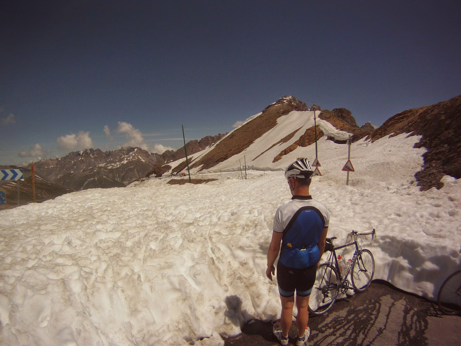 |
| Route definitely 'Barree!' |
What a place. Deep blue sky, brilliant white snow, imposing mountains all
around. A few other riders off to one
side taking photos but they soon leave and we’re the only people there. The
polar opposite to Mt Ventoux with its shops, car park and bustle.

Here there is nothing but some road signs and silence. I hear an eagle somewhere calling and that’s it. Still and very, very beautiful. But 48km from our campsite and what goes up for 3 ½ hours must come down.

Here there is nothing but some road signs and silence. I hear an eagle somewhere calling and that’s it. Still and very, very beautiful. But 48km from our campsite and what goes up for 3 ½ hours must come down.

Really concentrating now, if
Mt Ventoux was exhilarating then this is frightening, lower speeds offset with
a much bigger drop to the side, no option for failure here. Stop at the hotel
again, a knowing smile from the waiter as he serves us coffee this time to set
us up for the return down the valley. Over all too soon we’re back in the
campsite, 100 km of proper alpine riding completed and quietly planning next year’s trip…